
News
See What Roads In Kano Looked Like In 1970 (Photo)

photo credit: NigerianMuseum [Twitter]
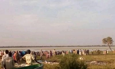
Kano State is a state located in Northern Nigeria. Created on May 27, 1967 from part of the Northern Region, Kano state borders Katsina State to the north-west, Jigawa State to the north-east, Bauchi State to the south-east and Kaduna State to the south-west.
The above picture is an aerial view of what roads in Kano looked like in 1970.
You may also like: See How Popular Roads In Lagos Looked Like In The Past (PHOTOS)
There are up to 9,383,682 people of diverse tribes and religious affiliations in Kano according to the last census conducted in the country. Kano State has been a commercial and agricultural State, which is known for the production of groundnuts as well as for its solid mineral deposits.


-

 Celebrities Auto7 days ago
Burna Boy’s ₦9 Billion Bugatti Chiron VXX Special Edition Arrives Nigeria
-

 News1 week ago
Speed & Smoke: The Best Photos From The 2026 Goodwood Hill Climb
-

 News5 days ago
Bugatti Wars: Davido Flaunts $5 Million W16 Mistral, A Day After Burna Boy’s Chiron Arrived Nigeria
-
 Car Theft1 week ago
Suspect Arrested After Trying To Smuggle Stolen ₦184M Toyota Land Cruiser Out Of South Africa
-
 News3 days ago
The Mazda MX-5 (Miata) May Become An EV
-

 Celebrities Auto2 days ago
₦6B Worth of Supercars: Jeff Forex And Habby Forex Takes Delivery Of Their Lamborghini Aventador SVJs
-

 Auto Fun1 week ago
Camperghini: Colorado Man Converts Lamborghini Urus Into Mobile Home, Takes It Across 40 Countries
-

 News1 week ago
8.0-Liter W16: After Powering 8 Models In 21 Years, Bugatti’s Iconic Engine Retires