
News
See What Roads In Kano Looked Like In 1970 (Photo)

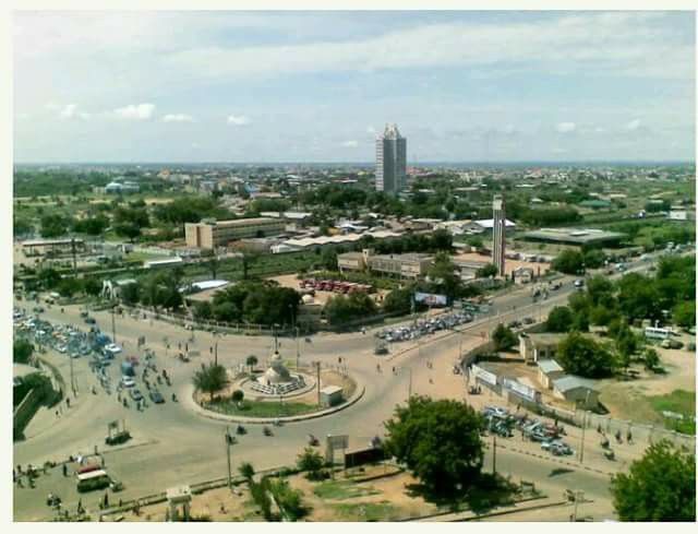
photo credit: NigerianMuseum [Twitter]
Kano State is a state located in Northern Nigeria. Created on May 27, 1967 from part of the Northern Region, Kano state borders Katsina State to the north-west, Jigawa State to the north-east, Bauchi State to the south-east and Kaduna State to the south-west.
The above picture is an aerial view of what roads in Kano looked like in 1970.
You may also like: See How Popular Roads In Lagos Looked Like In The Past (PHOTOS)
There are up to 9,383,682 people of diverse tribes and religious affiliations in Kano according to the last census conducted in the country. Kano State has been a commercial and agricultural State, which is known for the production of groundnuts as well as for its solid mineral deposits.














-

 Celebrities Auto1 week ago
Afrobeats Star Kizz Daniel Splashes ₦1.6 Billion On Brand New 2026 Ferrari Purosangue SUV
-

 News1 week ago
Top Auto News Last Week: Uber Exits Nigeria, Launches UK Robotaxi, Tesla Debuts Steering-Wheel-Free Cybercab, Kaduna Gov Unveils 2026 Peugeot 3008 And 5008
-

 Car Theft3 days ago
Fear Of Theft: Indian Man Hires Crane To Park New Mahindra SUV On Rooftop Before Traveling To Israel
-

 Celebrities Auto1 week ago
Burna Boy’s ₦9 Billion Bugatti Chiron VXX: The Making By Venuum
-

 News6 days ago
Mercedes-AMG CLE 646 Spezialanfertigung: Sold-Out 646-HP Collector’s Item Limited To Just 30 Units
-

 Business7 days ago
Mate Rimac Becomes Bugatti President Following Porsche’s Exit
-

 Auto Sport1 week ago
New Mercedes-Benz S-Class “140 Years. 140 Places” Global Tour Reaches Africa As Nigeria Misses Out
-

 Celebrities Auto5 days ago
Is This Asake’s New Ride? Inside the 1,001-HP Lamborghini Revuelto Venuum Voltoro V1 Spotted With Giran Republic Branding